
Starting at the top of the mountains, are the cirque glaciers. Mostly small, circular pools, these glaciers never crest over the summits. Those that are big enough to crest over mountain tops, and meander downward through the lane of least resistance of the mountain ranges, are called valley glaciers. In some cases, they spill into a piedmont glacier, which is the collection of valley glaciers that has pooled at the base of mountains. Imagine a huge, beautiful lake of ice! The Malaspina Glacier is very close to heavily visited Hubbard Glacier yet it can be seen in its entirety only from space. Over 1,500 square miles of ice! Valley glaciers that continue their meandering, and terminate in sea water, are also known as tidewater glaciers. See how this can get confusing?
On a recent cruise, one of our days was spent in Disenchantment Bay to view Hubbard Glacier. Because of heavy calving, we were unable to get closer than a mile away from this beaut. The face of the glacier, when one can get close enough, towers over the cruise ships at six miles across and over 300 feet high. Hubbard Glacier is the longest tidewater glacier in North America at more than 92 miles in length and it is one of the advancing glaciers of Alaska. Hubbard has closed off Russell Fiord from Disenchantment Bay on two occasions over time, and at present, the advance of the glacier has the Yakutat Natives very nervous. When it advances forward, it connects with Gilbert Point and cuts off the flow of water creating a lake. The fear is the water will rise, flood the Yakutat peoples land and cause disruption to the subsistence fishing in the area. The fiord rose 83 feet in 1986 before the calving of the glacier itself caused a breakthrough. In 2002, water rose 61 feet before the "dam" that was created broke through the terminal moraine of the glacier. This caused the world's second largest glacial flood as the fiord emptied back to the sea in less than 36 hours.
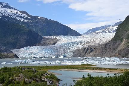
Ice Fields are large areas where many glaciers originate. The Juneau Ice Field is well known because it feeds Mendenhall Glacier in Juneau along with 37 other large glaciers. This is a popular tidewater glacier, but scientists believe at the rate it is receding it will be a hanging glacier by 2015. This meaning the glacier will hang over the very lake that it feeds. There are many trails to hike around the area, some that mark the points of ice as it has receded over the years. Pictures are easy to get, like this one taken also from my trip in 2011.
Of all the 100,000 glaciers in Alaska, only a little over 600 are named. Portage Glacier outside of Anchorage feeds off an un-named ice field, which is also easy to access. It has been receding and you can only see it by tour boat. The face itself is no longer visible from the visitor center although the icebergs that calve from it tend to float up to the shoreline there.
If you set the terminology aside and just witness these beautiful works of Mother Nature, you will not be disappointed. If you never know whether its tidewater or freshwater, its ok. Just appreciate youve had the chance to see a glacier in Alaska, of course.