Alternate Names: Djibouti
Former Names: French Territory of the Afars and Issas, French Somaliland
Capital City: Djibouti (city)
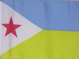 Flag: The flag is two equal horizontal bands of light blue (top) and light green with a white isosceles triangle based on the hoist side bearing a red five-pointed star in the center
 Date of Independence: June 27, 1977 (from France)
National Anthem: Djibouti (song)
Population: 506,221
Size/Area: 23,000 sq km, slightly smaller than Massachusetts
 Land Locked: No
Coastline: 314 km
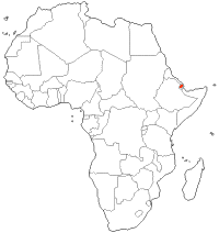
Bordering Countries: Eritrea, Ethiopia, Somalia
Administrative Divisions: 6 districts. Ali Sabieh, Arta, Dikhil, Djibouti, Obock, Tadjourah
Major Cities: ´Ali Sabîh, Dikhil, Jibûti, Tajûrah, Ubuk
Languages: French (official), Arabic (official), Somali, Afar
Religions: Muslim 94%, Christian 6%
Major Holidays: Independance Day
Currency: Djiboutian franc
Currency Code: DJF
Highest Point: Moussa Ali at 2,028 m
Lowest Point: Lake Assal at -155 m (Lake Assal is the lowest point in Africa)
Bordering Bodies of Water: Red Sea, Gulf of Aden
Bodies of Water: Lake Assal, Lake Abhe Bad
Climate: Desert, dry
Major Industries: construction, agricultural processing
Major Agricultural Products: fruits, vegetables; goats, sheep, camels, animal hides
Natural Resources: geothermal areas, gold, clay, granite, limestone, marble, salt, diatomite, gypsum, pumice, petroleum
Time Zone: UTC +3
 Tribes of Africa eBook
This eBook is the most complete listing of African tribes available on the internet. The first section of this book is the tribes sorted alphabetically by country. The second section is the tribes sorted alphabetically by tribe name.